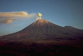
Mount Semeru or Mount Meru is a stratovolcano in East Java, Indonesia. Mount Semeru is the highest mountain in Java, with Mahameru peak, 3,676 meters above sea level (masl). Mount Semeru is also the third highest volcano in Indonesia after Mount Kerinci in Sumatra and Mount Rinjani in Lombok, east of Mount Agung. The crater at the summit of Mount Semeru known Jonggring Saloko. Mount Semeru is administratively included in the two districts, namely Malang and Lumajang, East Java Province. The mountain is included within the Bromo Tengger Semeru National Park.
 |
| Source : google.com |
Semeru has a forest area Dipterokarp Hill, Dipterokarp forest Upper Montane forest, and forest Ericaceous or mountain forests. Semeru geographical position located between 8 ° 06 'latitude and 112 ° 55' east longitude.
In 1913 and 1946 Crater Jonggring Saloka has a dome with a height of 3744.8 m to the end of November 1973. Adjacent to the south, this dome break edge of the crater caused lava flow leads to the southern side covers an area Pronojiwo and Candipuro in Lumajang.
At the peak of Mount Semeru (Mahameru) climbers are advised to not get to the crater Jonggring Saloko, also banned climbing on the south side, for their poisonous gas and lava flows. This poisonous gas known as Wedhus Gembel (Java which means "goat dreadlocks", which is like a hairy goat dreadlocks) by locals. Mahameru dipuncak temperature range 4-10 degrees Celsius, at the height of the dry season minus 0 degrees Celsius, and found ice crystals. The weather is often foggy, especially in the afternoon, evening and night. The wind blowing in from December to January is often a storm.
Gembel Wedus eruptions every 15-30 minutes at peak of Mount Semeru, which is still active. In November 1997 Mount Semeru erupted as much as 2990 times. During the day the wind direction to the summit, to avoid coming during the day at the top, because the toxic gas and the eruption leads to the summit.
The eruption in the form of white smoke, gray to black with a height of 300-800 meters eruption. Material that comes out at every eruption of ash, sand, gravel, rocks and even the heat is on very dangerous if hikers are too close. In early 1994 hot lava flowed south slopes of Mount Semeru and has incurred some casualties, although the river view hot winding towards the sea becomes a very interesting spectacle.
The first person to climb this mountain is Clignet (1838), a Dutch geologist from the southwest through Widodaren, hereinafter Junhuhn (1945), a Dutch botanist from the north through the mountain-ayek Ayek, Inder-inder mountains and mountain Kepolo. 1911 Van Gogh and Heim through the northern slopes and after 1945 generally done through the north slope climbing through Ranupane and Ranu Kumbolo today.


